April - A Hail Mary
April 28, 2019 - Cahokia Mounds
I'll be honest, this was a hail mary new thing. I've been struggling nearly every month to come up with something new to do. I've even asked numerous people and their ideas are usually great - but, either I've already completed them, or they don't fit in to my schedule. Btw, how the HELL did I find time to do a new thing EVERY. FREAKING. WEEK. a decade ago? I miss that energy and drive to complete all of those new things when I was 29.
But, this month, I was on the struggle bus. Some of the really cool things I've considered (trapeze, etc.) don't start until the warmer months, or things like a silks class or getting a fish pedicure didn't fit in to my schedule, nor could I find a reputable place in StL for fish to nibble my toes.
So, this month, I chose to head over to Illinois to Cahokia Mounds. It's actually been on my StL list for over a decade, and I've even considered taking my nieces for their birthday trips. But, it never really worked out, nor did I really think my nieces would like it. After a quick weekend trip to visit my brother, I opted to swing by this U.S. National Historic Landmark on my way home.
Here's the gist that I can tell you from the brochure I snagged. "As the largest prehistoric Indian site north of Mexico, Cahokia Mounds covered about 4000 acres and included at least 120 mounds. The State of Illinois now protects 2200 acres of the central portion of the site and 70 of the 80 remaining mounds. The site was named a U.S. National Landmark in 1965, and in 1982....was designated a World Heritage Site for its significance in the prehistory of North America."
As I pulled up, I immediately noticed the largest mound on the northern side of the road. I stopped first at the Interpretive Center to get my bearings, scrounge up a map and be on my way. They happened to be having a Native American art extravaganza going on, so it was filled with a variety of artisans selling their wares. Since I didn't see many people out walking the grounds, I imagine the full parking lot was due to the art fair and not the mounds themselves. After I arrived, I watched a short video on the rise of the civilization who lived here, the significance of the mounds and the decline hundreds of years later.
I'll give you the super paired down Cliff Notes highlights:
-The first settlements were around 700 AD by Late Woodland Indians.
-Around 1000 AD, the Mississippian culture began as highly structured communities arose with complex ranked social and political systems.
-From 1050-1200 AD, the population grew to 10-20,000 people, sprawling over six square miles. This was the largest community north of Mexico.
-The "Mounds" themselves were made of earth dug from nearby borrow pits and transported in baskets on people's backs.
-It's estimated that over 50 million cubic feet of earth was moved for mound construction alone.
-The rectangular platform mound was the most common, used to elevate ceremonial buildings and the residences of the elite.
-Conical and ridgetop mounds were used to mark important locations or burials of important people.
-Around 1200 AD, the population began to decline, and by the mid 1300s, it was nearly abandoned. The reason for the decline is unknown, but it could be due to depletion of resources, changes to political or economic power, disease or environmental changes.
-Although the site was named after the Cahokia tribe of the Illiniwek confederacy, they did not build the mounds and were late arrivals to the area during the 1600s.
Once I finished the video, took a quick tour around the museum (I could have easily spent a few hours here reading through all the exhibits and perusing the art vendors) and headed out to see the mounds first hand.
I will have to say that it was a gorgeous - albeit chilly/breezy - day, and there weren't many people out walking about. But, it was still underwhelming to walk around. The grass was either overgrown or patchy in places, the mounds were also overgrown with some bushes, etc., and I don't know, I was expecting more, I guess? Don't get me wrong, I LOVE the history of the place, but I guess I was expecting a bit more pomp and circumstance while walking around.
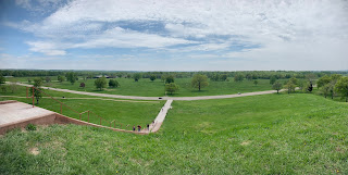
For obvious reasons (so as not to deface or disturb the earth), you couldn't walk up any of the mounds except the largest one (Monks Mound). So, I basically just wandered around an open field for 30 minutes, climbed Monks Mound (with the help of modern stairs), took some photos and left.
 |
| Intro video. |
 |
| The screen raised to reveal this exhibit. |
 |
| What Monks Mound perhaps used to look like. |
 |
| Woodhenge. |
 |
| 3 types of mounds. This is the Platform mound usually reserved for elevated buildings and important people. |
 |
| Conical mounds used for burying important people. |
 |
| Ridgetop mounds believed to be marker mounds. |
 |
| Interpretive Center. |
 |
| Gorgeous day! |
 |
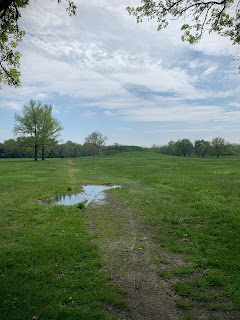
| We've had quite a bit of rain. |
 |
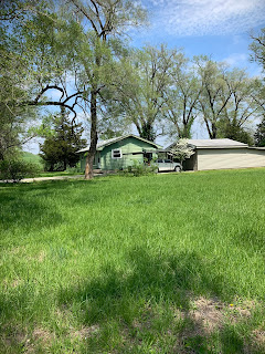
| There is a random house on the property...I have so many questions. |
 |
| One of the twin mounds. |
 |
| Partial reconstruction of the south stockade. |
 |
| One of the Twin Mounds - thought to be a mortuary complex (though no excavations have been made) and was built on top of a platform mound. |
 |
| Monks Mound where ceremonial buildings used to be. |
 |
| These modern steps were added for safety and are in the same location as the original stairs. |
 |
| Passing the first level. |
 |
| Twin Mounds and the Interpretive Center in the background. |
 |
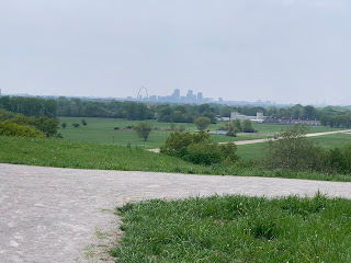
| I zoomed in a bit, but you can see the orientation of downtown St. Louis to the site. |
 |
| The Grand Plaza - where the heart of the city used to be. |
 |
| Trail markers. |
 |
| What remains of Woodhenge - what they used to help mark the seasons. |
 |
| Had to drive down the road a bit to get to Woodhenge. |
While this was a cool site and I'm so happy they've preserved its history, it wasn't exactly a huge bucket list item. But, it checked the box it needed to, and I can mark it off the list! (By the way, I grossly paired this blog down and didn't capture nearly enough history and photos. Stop by and see it to learn more!)


No comments:
Post a Comment